Sunday, January 8, 2012

Stupas of Kathmandu I: Swayambhu

I love looking at old city maps, nothing like the detailed and often hand-crafted(note not drafted!) cartographic masterpieces. They say so much about a place than words ever will. Unfortunately, not all places on earth have that luxury of documentation. I tried looking up maps for Kathmandu to study how the city has evolved through its history to its present state but alas! I could only go as far as 1960 but not further.  I have been trying to find maps, pictures of the city around the 1930s but haven't got my hands on those yet. So the next best thing is to look for old sketches (travelogues mostly) or accounts of Chinese travelers but that often lacks images, so its pictures and more pictures as the only source of authentic documentation of change. Since the most logical places to look for is pictures of monuments and public places- I'm going to begin this series with the Stupas of Kathmandu Valley - note that the archived documentation of these monuments goes back to the 11th century in some cases. To get this series off the floor, I'm starting with Swayambhu Stupa. Some of the recent pictures are mine but most of the older ones, I do not own them. These images are interesting because they give a fair picture of the urban expansion Kathmandu Valley has experienced within the last 50 years. If you have images you would like to contribute to this series, do contact me, I will gladly put up images(with due credit).

Location of Swayambhu Stupa (Courtesy Google Maps)

As a first, I'm putting up an old sketch by Daniel Wright.

Drawing by Daniel Wright - Date n/a

Swayambhu Stupa - 1920

Swayambhu Stupa - 1920

Swayambhu Stupa - 2007

Swayambhu Stupa - 2012

Swayambhu Stupa - 1960
The view of the valley (east) from Swayambhu - 2012

Base of  Swayambhu Stupa, north - 2007

At the base of the main flight of steps, east - 2012

Stupa on top - 2012

Looking back down towards the steps - 2012

Be prepared to see monkeys!...lots of monkeys infact

Southern side - 2012

View of the harmika and the pinacle - 2012

Prayer wheels around the base of the stupa

Maitreya Buddha circa 5th century, nw corner

The old and new - side by side

Smaller Chaityas on the main flight of steps, east - 2012

You can get your name sculpted on a rock


About the Stupa:


Sketch showing the location of major Stupas within the Kathmandu Valley.
Swayambhu Stupa has been highlighted.
Plan of the complex with main Stupa at center

Swayambhu 
plan showing the niches
housing the Tathgathas and their respective Shaktis

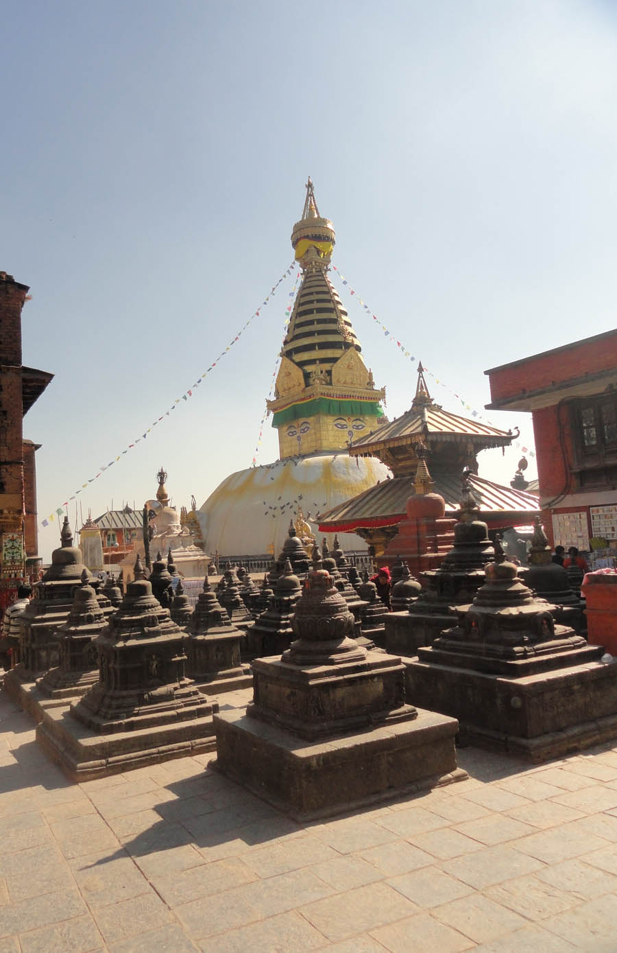
Perched on top of a hill, Swayambhu which means - self manifested is one of the oldest power spots within the valley. It is believed to have existed even when the valley was a lake (neolithic period). There are numerous flight of steps that lead you to the top but nothing beats the experience of walking through the front (east) flight of stone steps to see the stupa emerge on top. There is a parking lot half-way to the top at the western side of the hill, but you will still have to walk the rest of the way to the top albeit on steps which are fairly comfortable to walk (unlike the steps on the eastern side).

The white washed stupa is some 20 meters in diameter and supports a square gilded Harmika and a pinnacle of 13 gilt rings that culminate in a parasol. The 13 rings represent the 13 levels of perfection – the steps to attain enlightenment or nirvana. The five transcendent Buddhas, the Tathagatas occupy niches at the cardinal directions around the dome. On four cardinal directions, there are four shrines, not exactly facing E, W, N, S but deviating by a certain angle. The west shrine is the key shrine of Swayambhu (Aamitabh). There are also shrines in four corner directions, occupied buy the consorts (taras). The shrines have been added due course of time. The oldest ones are the four aadi Buddhas’ shrines on four cardinal directions. Each niche is a gilded temple in itself, reminiscent of the ceremonial gateways which gave access to the circumambulatory paths around stupas found in ancient India. The hemisphere of Swayambhu has a flattened area on top. There is a small drummed base (not much high). There is hermika with painted eyed and a toran on all four sides. Towards the east, on top of the flight of steps, there is a Bajra on a Dharmadhatu Mandala in front of Swayambhu made by Pratap Malla.

Updated on November 25, 2016

Although the main Stupa escaped the devastating twin quakes of April-May 2015 with minimal damage, the surrounding temples and structures weren't so lucky. Anantapur Temple was damaged to the point where it had to be brought down to the first level before repairs could happen. The monastery to the SW was damaged, as well as the structure west of the Harati Temple. The bhajan mandap in front of the stupa to its East next to the main staircase was also heavily damaged. The temple to the North of the main stupa has been closed off, its windows closed off with ply wood and sheer cracks adorn the building facade.

The viewing platforms to the SE were damaged extensively as as of November 2016 closed and cordoned off indefinitely.

View of mid level landing at the parking side (West stairs) 2016

Building to South, under repairs 2016

Foundation strengthening  (Nov. 2016)
Repair works underway (Dec. 4, 2016)

Metal channels to strengthen building (Nov. 2016)
Channels prepared to be put in place (Dec. 4, 2016)
Brick work around the metal C section
(Jan. 2017)


Fallen monuments Anantapur Temple (East) 2016

Anantapur Temple 2016

Damaged Temple front 2016

Awaiting reconstruction 2016


Repair works to a portion of the Eastern steps 2016


Looking up from the last leg of the East steps 2016

Tourism amidst the ruins 2016

Panoramic view of SW Kathmandu as seen from Swayambhu 2016

Damaged Bhajan Mandap (East) 2016


Temple to the North of the Stupa (NW staircase)
Structure was damaged in the April 2015 earthquake
(Nov. 2016)


Monastery to the West of the Stupa damaged
by the April 2015 earthquake (Nov. 2016)
SW Steps (Dec. 2016)

Chautari at SW steps (Dec. 2016)

Top steps on NW (Dec. 2016)

Top steps on SW (Dec. 2016)


Sunday, January 1, 2012

Streets

Happy New Year!
Images from my travels. Streets as an urban theater.


Saturday, December 31, 2011

Beauty is in the details

Life's been strangely busy, so much that I haven't had time to get properly started on the previous post so I've scrapped it for now. The best way I figured is to get started, and build on that so here it goes, pictures from the historic center of Kathmandu.


Decorative Struts - Building near Tahity

A Typical Temple in the Durbar Square

Garuda Statue
This seems more like a marker strangely out of place. Needs some research.


A home to so many ideas

1950s Detailing? There are lots of similar details in this area

'Bangemuda' Another square, another intrigue.
And its just a part of the ensemble, there's more.
Entrance to 'Chusya Bahal'


One more from a time-gone-by


Thursday, September 29, 2011

Sacred places, holy rivers and the public realm

My travels took me to three very special places; it wasn’t the busiest time of the year which meant that it was easier to observe the physical infrastructure in place to cater to the sea of humanity that descends upon those sacred rivers when the time comes every year. Water has always been an integral element in landscape architecture – from Mogul gardens to the gardens of Italian renaissance or the exquisite fountains that liter every nook and corner of Rome; every culture has a unique relationship between architecture and water thereby creating a unique urbanism. In Hindu Architecture,water is an integral part of the religion and a way of life. From time immemorial, sacred rivers and their importance have been reiterated in the sacred Vedas and other religious texts. 

When you put together landscape architecture and Hinduism, you cannot look far beyond the role of water or more specifically rivers – those sacred rivers and the ghats that provide access to them. Almost every major pilgrimage site has a holy river associated with it, and unmistakably a ghat that provides access to it. Ghats are an integral part of the culture where everything from holy bathing, various rituals, offerings to the gods, prayers, meditation, riverside temples, cremation of the dead, offerings for the well being of the departed souls, festivals, melas as well as deity visarjan takes place. In terms of evolution, most of these areas have evolved either by a spontaneous phenomenon over the course of time or more recently through specific design intentions and have become a threshold in terms of cityscapes.

Because of the growing population of our cities, the same activities and practices are placing tremendous stress on our river systems to the extent that they face severe ecological threats. So in that respect, if we are to ensure cultural continuity of any kind, we will need to device architectural solutions to ensure that the regular activities are not polluting the rivers while at the same time retaining the cultural values. It will be crucial to identify the issues associated with each specific place and then develop a mechanism and a plan to counter those problems. For instance, if your site attracts a huge floating population during certain times of the year – you need to take care of issues like way finding during peak hours, proper crowd management, traffic control, crowd control, proper signage, clearly marked entry and exit points as some of the basic criteria that needs to be fulfilled. The greater issues would be the safeguarding the river from any ecological threats.

It’s interesting to note that because of the nature of these ghats, there are only a certain degrees of commercialism that it can cater to lest it offends the same populace that it serves otherwise. But, if a healthy balance can be achieved, then perhaps making the waters commercially viable is another approach to ensure its continuity, perhaps!? Can you see yourself, sipping coffee like in Venice alongside the Grand Canal and observe the Gangaji? Is that too far fetched? But may be long term sustainability lies in merging the traditional with contemporary sensibilities? Okay not Coffee but certainly an icy cold Lassi, for sure!
Haridwar, India
The three Indian towns of Haridwar, Rishikesh and Badrinath provided three very distinct site resulting in unique spaces that were built around them accordingly. Haridwar, the largest and the most obviously organized amongst these three caters to huge numbers during Kumb melas as well as a regular flow of devotees who come to take a plunge in the famed Gangaji at Hari-ki-pauri. That combined with the regular evening aarti makes it an enriching experience. 

River Ganga, Rishikesh
Rishikesh on the other hand felt a lot more subdued while the mighty Ganga seemed the opposite here, visibly cleaner waters that was roaring unlike the calm waters of Haridwar. The place has beautiful ghats, temples and markets – and a large number of dharmashalas that provide housing to thousands of pilgrims every year. Alongside this flux of people, it felt like a lot more people come to Rishikesh for austere meditation – those that seek answers to bigger questions and seek for salvation still can be found meditating around this pious city. 

Laxman Jhula with the thirteen storey temple in the background
Rishikesh, India

Typical street market in Rishikesh

Badrinath, on the other hand was a world of its own, nestled amidst the beautiful Garhwal Himalayas, you feel no restraint in the flow of the mighty Alaknanda nor surprises in the presence of the hot springs which let people absolve their sins which they otherwise would not be able to do in the mighty but icy Alaknanda.

Irrespective of where each site is or the number of people it caters to every year – there seemed to be certain basic elements which were common to every place. They are –

  •          waters of the holy rivers,
  •         ghats that provide access to them,
  •         platforms for performing various religious rituals,
  •        provisions for bathing – men and women separately and preferably a changing room if possible,
  •          temples,
  •         presence of various kinds of trees which are considered holy and part of different religious functions and rituals,
  •         areas for quiet contemplative meditation,
  •         ghats for cremation although direct cremation alongside rivers is actively being discouraged in several places because of the pollution it creates (both air and water), so perhaps – an electric crematorium will be a norm in the days to come.
  • the lost soul in search of a truth or simply a spiritual aspirant in search of his spiritual guru.
Banks of River Ganga w/ Geeta Bhavan in the background
Rishikesh
In addition to the  sacred, the more earthly requirements these places fulfill are in successfully providing - 
  •         Dharmashalas and hotels so people can choose the appropriate accommodation according to their economic standing,
  •          places that serve clean and healthy vegetarian food,
  •         a local market that provides all the essentials necessary,
  •        and last but not the least easy means of transportation to and from these places
A word of caution about high altitude sickness, be sure to acquire basic knowledge about what exactly altitude sickness refers to and what to do in the event of one. Most importantly, always make a list of contacts who provide emergency services both via ground and air-lifts (mostly choppers). 

Sacred river confluences and beautiful Garhwal

It was the most unexpected trip of my life - traveling across Kumaon and Garhwal, India - the beautiful Silwalik range through some of the most revered Hindu sacred places culminating at the valley where the temple of Lord Badrinath exists at an altitude of 11,204 ft. The town lies in the between the Nar and Narayan mountain ranges and in the shadow of Nilkantha peak (6,560 m). Badrinath was re-established as a major pilgrimage site by Adi-Sankaracharya in the ninth century. This is one of the four major pilgrimage sites widely revered by Hindus across the world - Badrinath, Dwarka, Jaganath Puri and Rameshwaran. But it is also a wonderful place if you love adventure sports namely rafting and hiking. So it's not just a place for those seeking eternal salvation!

The landscape is truly breathtaking and as you travel higher up even blissfully peaceful, the roads are treacherous and risky. To be honest, risky would be a gross understatement, it was outright dangerous with all those landslides that seemed to crop up at every alternate turn.  The drive from Haridwar through Rishikesh to Badrinath normally takes around 8-10 hours (~301 km north of Rishikesh) given there are no hitches in the roads otherwise it may even take a few days, its not bad per say except you never know when or where the next road will be washed away.

All the way you travel through winding roads that run alongside the revered rivers Ganga and Alaknanda that rumble along majestically. There are five sacred river confluences along this route from Rishikesh to Badrinath. River Alaknanda first meets with the sacred Saraswathi river just before the town of Mana then meets Dhauliganga at Vishnu Prayag, the next river confluence is Nand Prayag where the River Nandakini meets the main river Alaknanda, Karn Prayag follows next with the river Pindar meeting Alaknanda river at this confluence. The fourth confluence is formed by the merging of river Mandakini with river Alaknanda at Rudra Prayag. The final Prayag in this series of five is the revered Dev Prayag where rivers Alaknanda and Bhagirathi come together - beyond this confluence the river comes to be known as river Ganga. The importance of this particular Prayag is considered equal to the Prayag at Allahbad where the mighty rivers Ganga, Yamuna and Saraswathi meet. 

Early morning, start of a beautiful journey
The term 'Prayag' in Hindu tradition signifies the confluence of two or more rivers where ablutions before worship, religious rites called the Shraddha (the last rites) for the departed as well as the worship of the river as a manifestation of God takes place. 

If you care to hike about an hour from Badrinath, you will also witness the rare sight of the mighty river Saraswathi as it emerges briefly only to sink into a crevice deep into earth. A little further below lies the town of Mana where India's last tea shop exists close to the Chinese border. In fact, Badrinath is not the only sacred place here, at the altitude of 15,200 ft is the sacred HemKund Sahib, a pilgrimage center for Sikhs in the Chamoli district of Uttarakhand. In between all this, I heard quite a few things about one site in particular known as the Valley of the Flowers renowned for its meadows of alpine flowers - a near mystical place with equally mystical prowess. 
The lower town, Badrinath and River Alaknanda
No matter how you travel, when you reach the valley of Lord Badrinath, you feel vindicated by the bliss, peace and the energy of the place. They say, this is the only place from where the roads to heaven exist, for it was through these valleys and gorges that the mighty Pandavs strode towards heaven; the little town of Badrinath with the majestic Alaknanda river felt like nothing less.

Monday, August 8, 2011

Tudikhel - the last 'green' standing?

Scalar Comparision of this core of Kathmandu with Central Park, NYC


At the center of Kathmandu stands a lonely patch of green with an almost forlorn, deserted look to it - Tudikhel. Probably one of the last remaining public green spaces in the city, its value is immense.But its like one of those things, in the midst of constant changes even while its locked in a strange permanence of sorts and always fighting a battle,a search for its identity. What is Tudikhel to the people of the city - if its more than just an open space, why haven't any steps been taken to organize this chunk of land into a green oasis in the middle of a truly concrete jungle? At one point of time, it stretched from Tripureshwor to Bhotahiti capped by Pratap Malla's marvelous sixteenth century pond(Rani Pokhari); it's been fragmented to Ratna park, Khula Manch, Sainik Manch, Tudikhel today. 

It was used for relief & rescue works, temporary camping sites following the devastating earthquake of 1934. Irrespective of its present condition, if you think about it, this stretch from Tripureshwor to Rani Pokhari all the way to the Garden of Dreams has tremendous potential to be developed as a major urban space which may even be a catalyst for the revitalization of the entire area. This spine can eventually be linked to the river and ultimately to the existing monuments scattered throughout the  Bagmati river bank and other development plans - mainly focussing on re-integrating the river to the city as well as creating more usuable pubic space, which would no doubt go a long way into salvalging the image of this city. The Guest House at the banks of the River Bagmati has its own significant history and its immediate area can be used to open up the city to its rivers and through it to an invaluable past - one that links right back to the start.
Pedestrian connection between Khula Manch (Public Stand) & Sainik Manch (Army Stand)


Garden of Dreams next to the Kaisher Mahal as the northern edge and a gate-way to Thamel cab be the Northern bookend of this urban spine. Given the relatively small size of this ground, you wouldn't think, it would take a lot to work out a proper development plan.


Tudikhel from the top of CTC Mall
Looking NE
View of the Army Parade area next to stands
Looking SW


Looking at the overwhelming rate of increased construction work in this city, its surprising that this has remained unscathed to the extent that it has over the years but the answer lies in the mysteries that surrounds almost every nook and corner of this valley. Yes, like many other things in Kathmandu, this place is very much associated with various myths and legends, which perhaps goes a long way to explain why this still exists.Of those myths and legends, the most famous is that of the demon Tundi from which the ground gets its name. In the story, the demon had spread terror and panic among the town’s inhabitants. The demon was eventually killed and buried, and horses were let loose over its grave to avert its resurrection. This is the origin of the annual Ghode Jatra or the horse festival, which still takes place in the month of March. The Tudikhel accommodates the grave of another demon, known as Gurumapa, who according to the legend also spread terror in the area. Legend says that it is the Gurumapa who does not allow three bricks to stand on one upon another at Tudikhel, and therefore, to this day, the land has remained free of any considerable building construction. The Tudikhel has also been used as a Parade Ground by the army from at least as early as the mid 1830s. 


At the South-West Corner of Tundhikhel


And then there are the Nameless Horsemen (unless you are a student of history, a plaque here would be useful), who stand as testimony of a time long gone. Irrespective of the past, the artistic value of these marvels in stone cannot be denied. Here are are two of those statues you can find near Shahid Gate.


At the North-West corner of Tudikhel beyond Shahid Gate
(Street Level View)


At the South-East corner of Tudikhel beyond Shahid Gate next to Bhadrakali Temple

At the North-East corner of Tudikhel next to old bus park


Historical pictures show how the Tudikhel was a place of refuge and home to many of the old city residents following the 1934 earthquake. My grandfather who was then an eleven year old boy has narrated his own experiences of surviving that day. I didn't think I'd live to speak of another harrowing day and months that followed. As the valley was repeatedly hit by aftershocks, residents whose homes had either been damaged or those people who felt unsafe to go back to the narrow lanes of the old city, lived in make-shift tents at Tudikhel for months following the 2015 earthquake. It reiterates the importance of this piece of land, and why we have to fight tooth and nail to preserve it, for the future.


Temporary tents provided an immediate respite
(July 2015)


Tudikhel as a place of refuge
(July 2015)

Tudikhel as a place of refuge
(July 2015)